


Hudson Voting District, Newton County, Arkansas
About
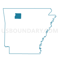
Outline

Summary
| Unique Area Identifier | 527451 |
| Name | Hudson Voting District |
| County | Newton County |
| State | Arkansas |
| Area (square miles) | 22.59 |
| Land Area (square miles) | 22.51 |
| Water Area (square miles) | 0.08 |
| % of Land Area | 99.64 |
| % of Water Area | 0.36 |
| Latitude of the Internal Point | 35.94902440 |
| Longtitude of the Internal Point | -93.24063350 |
Maps


Graphs
Select a template below for downloading or customizing gragh for Hudson Voting District, Newton County, Arkansas


Neighbors
Neighoring Voting District (by Name) Neighboring Voting District on the Map
- Jackson Voting District, Newton County, AR
- Lincoln Voting District, Newton County, AR
- Low Gap Voting District, Newton County, AR
- Mt Sherman Voting District, Newton County, AR
- Murray Voting District, Newton County, AR
- Pleasant Hill Voting District, Newton County, AR
- White Voting District, Newton County, AR
Top 10 Neighboring County Subdivision (by Population) Neighboring County Subdivision on the Map
- Jackson township, Newton County, AR (1,620)
- White township, Newton County, AR (830)
- Pleasant Hill township, Newton County, AR (386)
- Hudson township, Newton County, AR (327)
- Low Gap township, Newton County, AR (268)
- Lincoln township, Newton County, AR (248)
- Murray township, Newton County, AR (172)